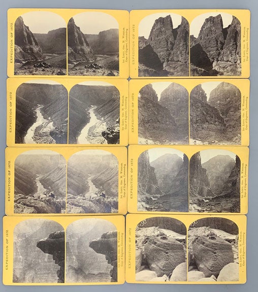
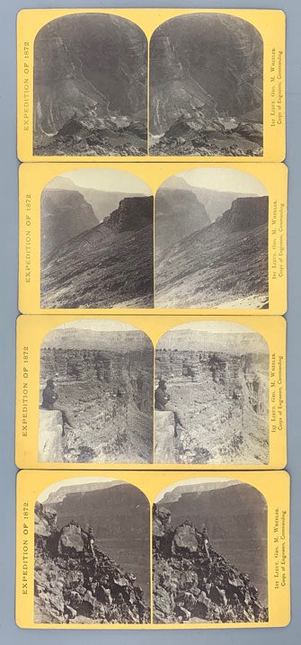
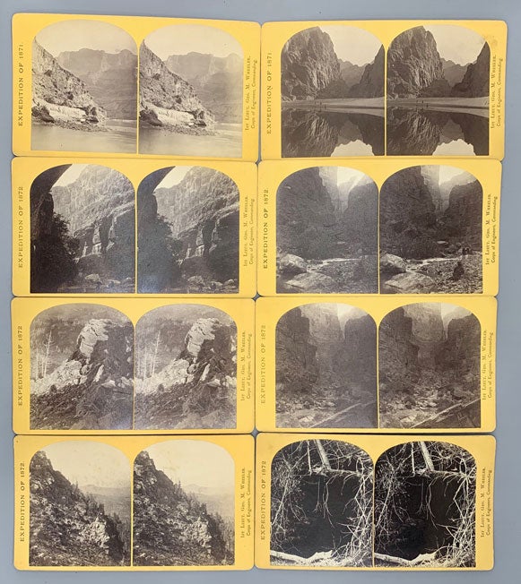
George M. Wheeler Survey Stereoview Collection. 20 Stereoviews
Washington DC: Geographical and Geological Explorations and Surveys West of the 100th Meridian, 1871-1872. Albumen photographs [9.5 cm x 15 cm] on yellow Geo. M. Wheeler mounts [10 cm x 18 cm] each with a printed identification label on the verso. 18 views by Bell; 2 by O'Sullivan. The majority are in remarkably nice condition, displaying strong contrasts.
Spectacular views from the Wheeler survey of the southwest with well focused images of the Grand Canyon, Kanab Creek, Black Canyon, Dirty Devil and Marble Canyon. These constitute some of the earliest images of these places.
Timothy O'Sullivan worked on the Wheeler Survey after having achieved some notoriety for his Civil War photographs. The work which O'Sullivan produced during this time was later used as a means of persuading Congress to fund military rather than civilian expeditions.
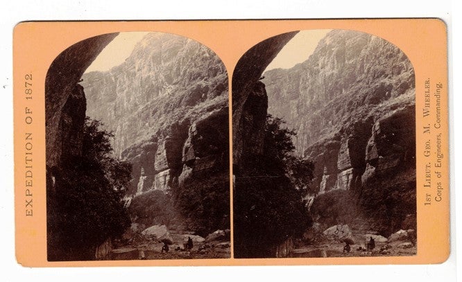
William H. Bell (1830-1910) was an English-born American photographer, who fought in the Civil War, and was mostly active during the second half of the 19th century. His Civil War views gained him much attention, and following the Civil War he was appointed chief photographer of the Army Medical Museum in Washington D. C. It was Bell and his assistants who printed the photographs that were featured on the "Wanted" posters for the Lincoln Conspirators, circulated following the assassination. Eventually, Bell set up a studio in Philadelphia, and in 1872, Lieutenant George Wheeler, engineer of the fourth United States Geological Survey, employed him to photograph his expedition into Arizona. Bell's images of the southwest taken during the 1872 Wheeler expedition served to strengthen his reputation as a photographer even further. Jeremy Rowe, in his book "Arizona Stereographs 1865-1930," writes with regards to the photography of this era, "... both surveys [Wheeler and Powell] produced and used the stereographs in their attempts to obtain congressional funding and for general promotion of the expedition to generate public interest and support. For example, Wheeler images were available as individual cards or as boxed sets of stereographs of the expedition." The 20 stereoviews presented here are examples of this promotional material.
This lot includes the images listed below:
[Expedition of 1871]
No. 9. View down Black Canon from Mirror Bar. The walls repeated by reflection. [O'Sullivan]
No. 15. View in the Grand Canon of the Colorado. Characteristic walls 5,000 feet in height. [O'Sullivan]
[Expedition of 1872]
No. 5. View in the high country, on the headwaters of the Dirty Devil River. The Rocks in the foreground are volcanic, and the trees are the Douglass spruce. [Bell]
No. 7. View in the high country, on the headwaters of the Dirty Devil River. The rocks in the foreground are volcanic, and the trees are the Douglass spruce. [Bell]
No. 9. Cave near Kanab, U.T. [Bell]
No. 14. The Canon of Kanab Creek, near its junction with the Grand Canon of the Colorado. In the foreground is a dripping spring, affording a shower-bath. Temperature, 69° Fahr. [Bell]
No. 16. The Canon of Kanab Creek, near its junction with the Grand Canon of the Colorado River. The walls are of limestone and about 2,500 feet in height. [Bell]
No. 17. The Canon of Kanab Creek, near where it joins the Grand Canon of the Colorado. The walls are of limestone and about 2,500 feet in height. [Bell]
No. 18. The Canon of Kanab Creek, near where it joins the Grand Canon of the Colorado. The walls are of limestone and about 2,000 feet in height. [Bell]
No. 20. The Canon of Kanab Creek, near where it joins the Grand Canon of the Colorado. The walls are of limestone and about 2,500 feet in height. [Bell]
No. 22. The mouth of Kanab Creek. The beds of the Colorado River and its tributary here lie in gorges cut by the running water to a depth of about 3,500 feet below the general surface of the country. The highest point seen in the picture is $2,500 feet above the water, and the walls are here too steep to be scaled. [Bell]
No. 23. Sand sculpture. The limestone boulders which lie in the bed of the Colorado River are carved and polished by the sand which the running water carries. [Bell]
No. 27. Colorado River, above the mouth of the Paria. Walls 2,100 feet in height. [Bell]
No. 28. Marble Canon, one of the gorges of the Colorado, here 1,200 feet deep. The steep cliff is gray limestone and the slope below a brilliant red sandstone. [Bell]
No. 29. Marble Canon, one of the gorges of the Colorado, here 1,200 feet deep. The steep cliff is gray limestone and the slope below a brilliant red sandstone. [Bell]
No. 31. Devil's Anvil, near foot of To-ro-weap Valley. River 3,000 feet below. [Bell]
No. 32. The northern wall of the Grand Canyon of the Colorado, near the foot of To-ro-weap Valley. The rounded rocks of the foreground are sandstone. [Bell]
No. 35. The Grand Canon of the Colorado, near the foot of To-ro-weap Valley. A view of the south wall of the gorge, as seen from the opposite side. [Bell]
No. 38. The Grand Canon of the Colorado, near the foot of To-ro-weap Valley. A view of the south wall of the gorge, as seen from the opposite wall. [Bell]
No. 39. Grand Canon, foot of To-ro-weap Valley. [Bell]. Item #57855
Price: $2,000.00